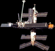
If you've never seen a real, live spacecraft orbiting the earth, well now's your chance! The Russian space station Mir can easily be spotted with the naked eye, and in fact is brighter than most of the stars you can see. You would probably mistake it for an airplane if you didn't know better--except that it has no little blinking lights, and it doesn't make any noise!
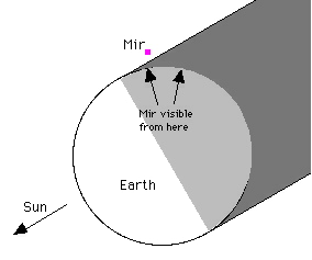 Mir is visible because of the sunlight that reflects off it. That means that certain conditions must exist before we on earth can see it:
- It must be dark down here (not even Superman can see Mir in the daytime, because of the glare of the sky);
- It must be light up there. The sun must be shining on Mir so that we can see the reflected light.
Because of this, the times you're most likely to see Mir are for a little while after sunset, and a little while before sunrise. At other times, either our sky will be too bright, or Mir will likely be in the earth's shadow.
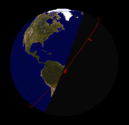
Mir's orbit on May 26, 1998
|
And of course, the other condition is that Mir has to be flying over your part of the earth at the time! Fortunately, Mir is in a "high-inclination" orbit, which means it reaches far northern and southern latitudes. This orbit, combined with the earth's rotation, means that Mir passes over most places on the earth fairly regularly (typically several times each day, for any given spot). On average, the lighting conditions at your location will be right for viewing every few days or so. However, during certain auspicious times around summer, when Mir's orbit lines up pretty closely with the earth's "terminator" (the dividing line between the earth's light & dark half), Mir can actually remain in sunlight during its entire orbit. At times like that, it may be visible as much as three or four times in a single night!
Most people are surprised to see how fast Mir moves through the sky. When it's passing directly overhead, if you hold your hand out at arm's length, Mir will cross the width of three fingers in about five seconds. It's traveled about 25 miles in that time!
Viewing Tips
You can often see Mir through binoculars even when it's too dim to see with the naked eye. The following things affect its visibility:
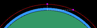
- Angle above the horizon. Mir is difficult to see when it's very close to the horizon. As shown in the illustration, this is for two reasons: (1) The light has to travel through more miles of air; and (2) Mir is much farther away when it's near the horizon than when it's overhead.
- Angle of the sun. Mir is easier to see when it's illuminated from the front than when it's backlit. You can often see dramatic changes in brightness during a single passage, as Mir's angle with the sun changes. Mir always travels more or less west to east: during a morning passage, it's moving toward the sun, so it starts out quite bright and then gets gradually dimmer. During an evening passage, the opposite is true: It's moving away from the sun, so it starts out rather dim and then gets brighter.
- Brightness of the sky. Mir is hard to see if there's too much daylight in the sky. The lights of a big city can have a negative effect too.
- Orientation of the spacecraft. Some parts of Mir are shinier than others. Its solar panels are particularly reflective. If Mir is turned at just the right angle, it will be so bright for a few seconds that you'll point and say "Oooooohh!"
How far away is it?
Mir orbits at an altitude of about 235 miles (sometimes a little more, sometimes a little less, because its orbit is not a perfect circle). But its distance away from you could be a great deal more than that, depending on its angle above the horizon (see the illustration above). This angle is called the "elevation angle" or the "altitude angle," and ranges from 0° (right on the horizon) to 90° (directly overhead). If you know this angle, you can get a good estimate of Mir's "Line-of-sight" distance. See the table.
Is it over my city?
The "Ground-track distance" is the distance along the ground between your position and the spot that's directly underneath Mir. If you know the ground-track distance and the compass direction to Mir, then you can look on a map to see what city it's passing over. The ground-track distance can be estimated from Mir's elevation angle: see the table.
This section will be updated every week or so with charts for predicted sightings of Mir from selected cities (selected because I have friends and family who live there :-). If your city is not on this list, check out these excellent sites:
If your Web browser can run Java programs, then try NASA's J-Pass program. It predicts the visibility of Mir and dozens of other satellites from many cities, and even lets you enter your own latitude and longitude if your city's not listed. It even draws charts (not as pretty as mine, though :-).
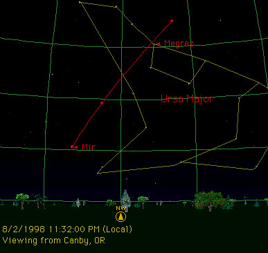
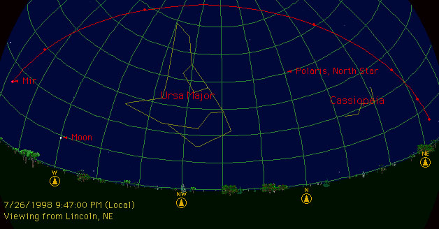
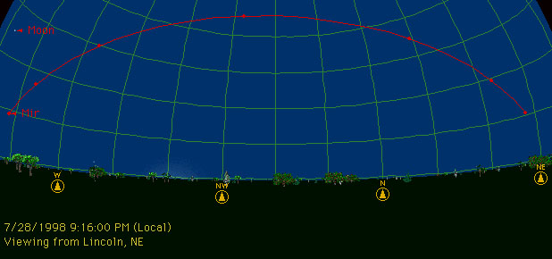
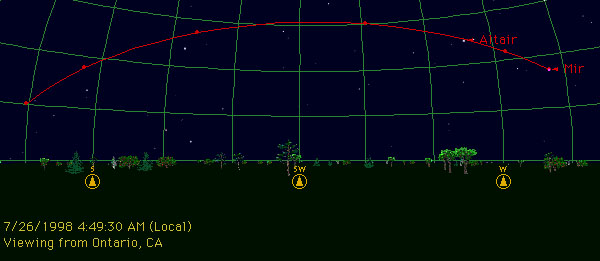
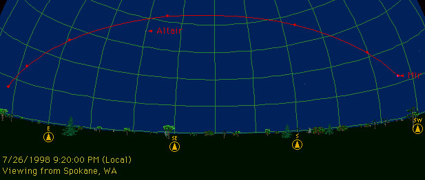
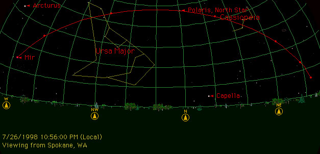
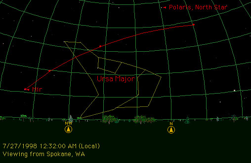
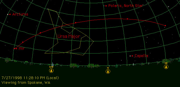
How to read the charts
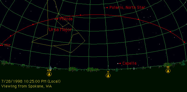
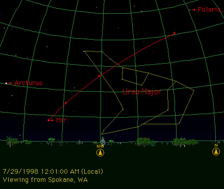
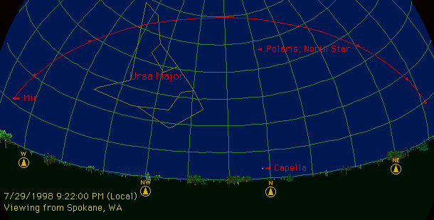
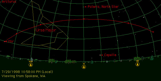
The red arc shows Mir's predicted path through the sky. The time displayed in the corner of the chart shows roughly the time at which Mir will first become visible; at that time, it will show up at one end of the arc (at the end labeled "Mir,") and will begin moving toward the other end. The red dots on the arc show Mir's position at 1-minute intervals.
The scale of these charts varies greatly. Use the grid lines to get an accurate idea of how much of the sky is involved:
- The grid lines that run parallel to the horizon tell you the "elevation angle" (the angle above the horizon). These lines are 10 degrees apart. You can use these to tell how high Mir will get in the sky. You can also use them to estimate Mir's line-of-sight distance and ground-track distance, using the table.
- The grid lines that run perpendicularly into the ground tell you the "azimuth" (the compass direction). These lines are 15 degrees apart.
Mir always moves more or less west to east: in some charts, that will be left to right; in others, right to left (depending on whether it's in the northern or southern part of the sky). Compass directions are displayed along the horizon.
You may notice that sometimes the "path" seems to start or end while Mir is still high in the sky. This usually means that Mir is entering or leaving the earth's shadow at that point. (This actually looks pretty cool--you can watch Mir "fade in" or "fade out" in a matter of just a couple of seconds).
Predictions for
Sunday, July 26 through Sunday, August 2, 1998
These lists show the date and local time of the beginning of the sighting, and the maximum elevation above the horizon that Mir will reach (I haven't included any sightings that don't get above about 30°, because they're very hard to see). Just click on any listed sighting to see its chart. All of these charts were generated using Sienna Software's "Starry Night Deluxe" program.
Click on a city name to generate a 10-day forecast that also includes low-elevation passes.
-
Canby, Oregon
-
Fort Worth, Texas
-
Lincoln, Nebraska
-
Ontario, California
-
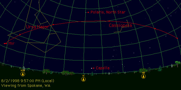
Spokane, Washington
- 7/26, 9:20 pm (43°). First of 3 tonight.
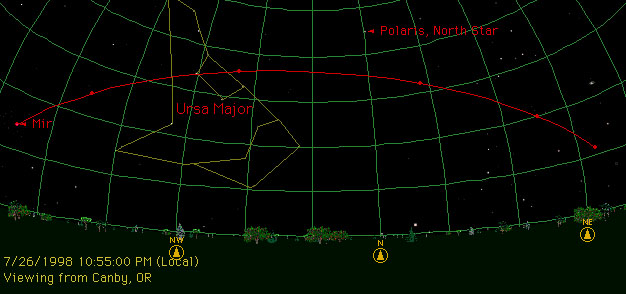
- 7/26, 10:56 pm (48°). Close encounter with the North Star.
- 7/27, 12:32 am (37°)
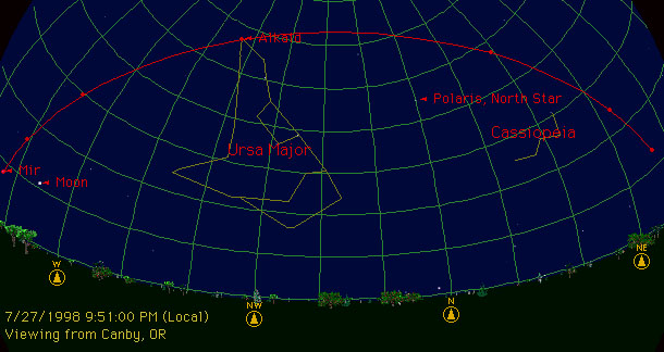
- 7/27, 9:52 pm (74°)
- 7/27, 11:28 pm (37°)
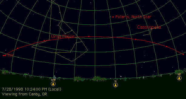
- 7/28, 10:25 pm (42°). Close encounter with Phecda in the Big Dipper.
- 7/29, 12:01 am (40°)
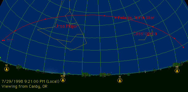
- 7/29, 9:22 pm (59°)
- 7/29, 10:58 pm (37°)
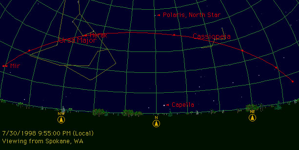
- 7/30, 9:55 pm (39°). Close encounter with Merak in the Big Dipper.
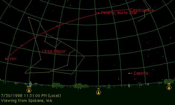
- 7/30, 11:31 pm (47°). Close encounter with the North Star.
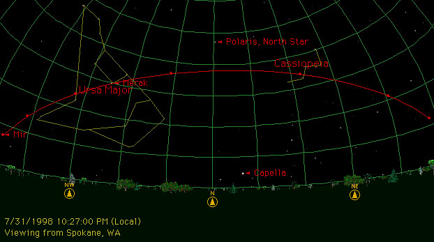
- 7/31, 10:27 pm (38°). Close encounter with Merak in the Big Dipper.
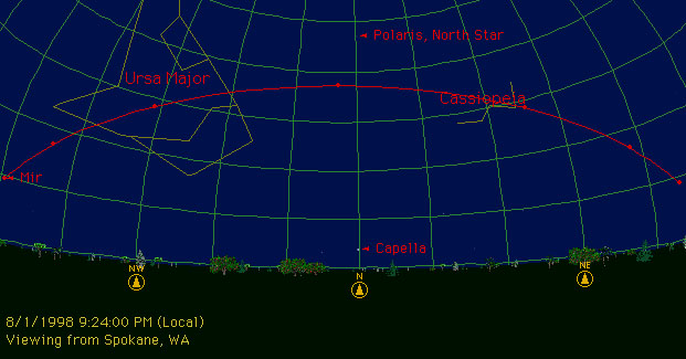
- 8/1, 9:24 pm (37°)
- 8/1, 11:00 pm (56°)
- 8/2, 9:57 pm (41°)
-
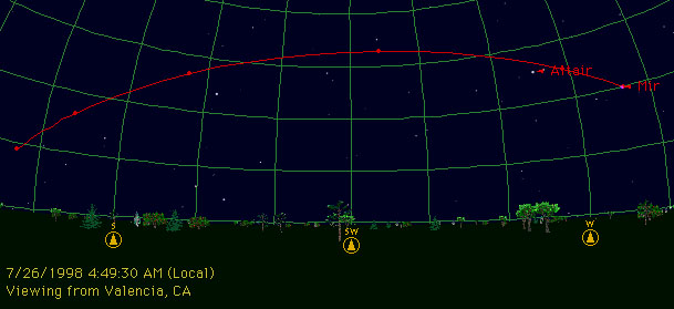
Valencia, California
-
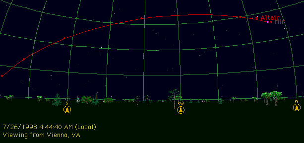
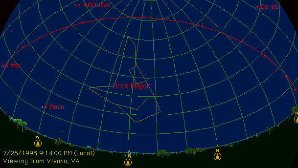
Vienna, Virginia
More Mir Links
